Tuesday, January 18, 2011
Connemara Geology - Dalradian
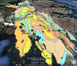
This map shows the Connemara Dalradian Metamorphic map in Google Earth - with a cross section of the northern limb of the Connemara Anticline. (I created this KML file in 2008).
Open KML File in Google Earth
Saturday, January 8, 2011
New GEO-Education website
I have uploaded a selection of Google Earth visualisations on a new GEO-Education website GeoNEED.
The website is provides some very interesting Google Earth maps and photo tours.
The GeoNEED website was launched as part of an international project (Northern Environmental Education Development) between Ireland, Finland, Norway and Iceland.
The website is provides some very interesting Google Earth maps and photo tours.
The GeoNEED website was launched as part of an international project (Northern Environmental Education Development) between Ireland, Finland, Norway and Iceland.
Mines and Quarries in the Burren
This Google Earth KML file shows the mineral extraction and quarry locations in north Clare and southwest Galway.
Open KML file in Google Earth
Open 3D KML Model in Google Earth
Open KML file in Google Earth
Open 3D KML Model in Google Earth
Friday, January 7, 2011
River Corrib railway viaduct 3D model in Google Earth
This Google Earth model shows the Midland Great Western Railway (MGWR) viaduct over the Corrib River in Galway. The bridge was dismantled in 1935. The three bridge posts remain in the Corrib River.
Open 3D KML Model in Google Earth
Subscribe to:
Posts (Atom)